
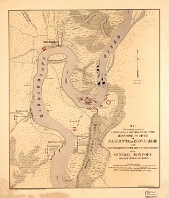
Island No 10›Map showing the system of Confederate fortifications on the Mississippi River at Island No. 10 and New Madrid, also the operations of the United States forces under General John Pope, against these positions / Published by au
- Publication:
- US, Civil War Maps, 1861-1865
- Region:
- Mississippi River
- Location:
- Island No 10
- Title:
- Map showing the system of Confederate fortifications on the Mississippi River at Island No. 10 and New Madrid, also the operations of the United States forces under General John Pope, against these positions / Published by au
- Source:
- Library of Congress Geography and Map Division Washington
- Description:
- [Blank]
- Conflict Period:
- US Civil War
View the actual high resolution document.
About US, Civil War Maps, 1861-1865
Maps, charts, and atlases depicting battles, troop positions and movements, engagements, and fortifications during the Civil War, 1861-1865.
Source Information
Forces War Records, US, Civil War Maps, 1861-1865 (https://au.forceswarrecords.com/document/260560468/map-showing-the-system-of-confederate-fortifications-on-the-mississippi-river-at-island-no-10-and-ne : accessed 29 Apr 2024), database and images, https://au.forceswarrecords.com/document/260560468/map-showing-the-system-of-confederate-fortifications-on-the-mississippi-river-at-island-no-10-and-ne
- Publication Title
- US, Civil War Maps, 1861-1865
- Total Records
- 1,933Complete: 100%
- Content Source
Fold3
- Published on Forces War Records
- 20 May 2010
- Last Updated
- 18 November 2011
Related Records
Related Publications
- US, The Horse Soldier Civil War Collection of Military Artifacts, 1861-1865
- Civil War Stories
- US, General Court Martial of Gen. George A. Custer, 1867
- US, Subject File of the Confederate States Navy, 1861-1865
- US, Official Records of the Union and Confederate Navies, 1861-1865
- US, Maine, Burial Records of the Togus National Home for Disabled Veterans, 1874-1938
- US, Weekly Returns of Enlistments at Naval Rendezvous ("Enlistment Rendezvous") Jan. 6, 1855-Aug. 8, 1891
- US, New Hampshire, Revolutionary War Records, 1675-1835
- US, Washington State Military Records, 1855-1950
- US, Adjutant General Military Records, 1631-1976
- See all publications